
Auf den höchsten Gipfel - mit Hund!
Die Zugspitze ist mit 2.942 Metern der höchste Berg in Deutschland. Kann man sie mit einem Hund erwandern? Auf einer Strecke von 23 km sind 2.400 Höhenmeter zu überwinden. Die gesamte Wanderung dauert etwa 10 Stunden. Ja, es ist möglich, diesen Berg mit einem Hund zu erwandern. Wie wir das gemacht haben, erzählen wir Ihnen in diesem Artikel.
Wissenswertes
Die Zugspitze, mit einer Höhe von 2.962 Metern, ist der höchste Berg Deutschlands und einer der höchsten Berge Europas, die ohne Kletterausrüstung bestiegen werden können.
Seit mehreren Jahren hegte Jo den Wunsch, zur Zugspitze zu wandern, und dieser Wunsch hat sich nun auch fest in Georgs Gedanken verankert.
“Aber wie schafft man das mit einem Hund? Ist das überhaupt möglich?”
Der Aufstieg von Garmisch-Partenkirchen dauert etwa 10 Stunden zu Fuß und erstreckt sich über etwa 23,6 km mit einem Höhenunterschied von 2.400 Metern. Es ist eine echte Herausforderung, weshalb eine Übernachtung in einer der Berghütten oft empfohlen wird. Für uns war eine Übernachtung jedoch keine Option aufgrund einer vorherigen Reservierung auf der Hütte und um flexibel auf die sich ändernden Wetterbedingungen, insbesondere mit unserem Hund, reagieren zu können. Beachte, dass Hunde in Hütten oft nicht willkommen sind, daher solltest du vorher im Internet nachprüfen.
Da wir nicht denselben Weg zurückwandern wollten, entschieden wir uns für den “bequemeren Weg” und nahmen die Seilbahn ins Tal. Es ist jedoch wichtig zu beachten, dass die Seilbahnen von der Zugspitze nur bis zu einer bestimmten Uhrzeit abends betrieben werden, in unserem Fall war es 17:45 Uhr. Die Partnachklamm (die Teil der Route sein könnte) öffnet regelmäßig um 8:00 Uhr morgens. Daher empfehlen wir, die Klamm separat zu besuchen, um mehr Zeit zu haben, sie zu genießen. Während des Aufstiegs zur Zugspitze kannst du entweder die Klamm umgehen oder den von uns gewählten Weg nehmen.
Die Strecke
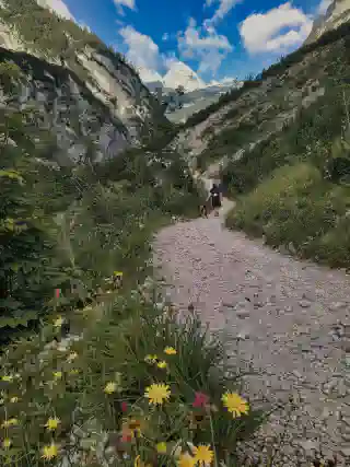
Von Garmisch zur Partnach-Alm
Um frühmorgens loszulegen, entschieden wir uns für einen Parkplatz, auf dem wir bequem übernachten konnten, unsere Autos sicher stehen lassen und nach der Wanderung ohne lange Rückwege leicht zurückkehren konnten. Den empfohlenen Ausgangspunkt an der Olympiaschanze ließen wir aus, da der Parkplatz dort nicht angenehm war und kostenpflichtig.
Am Vorabend packten wir unsere Rucksäcke, einschließlich Momos, der Essen, Wasser, Vaseline und notwendige Erste-Hilfe-Materialien enthielt.
Als der Wecker um 4:30 Uhr klingelte, waren wir alle noch etwas verschlafen, und Momo schaute uns an, als ob wir verrückt geworden wären. Halb schlafend stellten wir die Espressomaschine auf den Herd, zogen uns an, genossen eine kleine Schüssel Müsli, tranken Kaffee und putzten unsere Zähne - und dann ging es los.
Unsere Route, beeinflusst von unserem Ausgangspunkt, führte uns vom Wellenbad zur Kochel-Alm und dann zur Partnach-Alm. Die empfohlene Route führt normalerweise durch die Partnachklamm, aber im Juni 2021 war sie aufgrund eines Sturms geschlossen.
Als die Sonne aufging, kamen wir an der Kochel-Alm vorbei. Kurz bevor wir die Partnach-Alm erreichten, kreuzte sich unsere Route mit der vom Touristeninformationszentrum empfohlenen, und hier trafen wir die ersten Wanderer, die vermutlich auch um 5 Uhr morgens von der Skisprungschanze gestartet waren.
Ab der Partnach-Alm entsprach unsere Route der Empfehlung des Touristeninformationszentrums.
Partnach-Alm - Reintalangerhütte
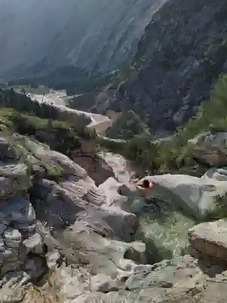
Von der Partnach-Alm aus setzten wir unsere Wanderung fort und gingen durch die Laubhütte, Bockhütte und Reintalangerhütte. Der Aufstieg zur Reintalangerhütte war einfach und gut gepflegt. Wir konnten uns bequem an den Ufern der Partnach im Schatten ausruhen. Bisher lief alles gut, und wir waren schneller unterwegs als die Wegweiser angaben. Allerdings hatten wir bisher nur einen Höhenunterschied von 600 Metern auf einer Strecke von 16 km geschafft.
Reintalangerhütte - Sonnalpin
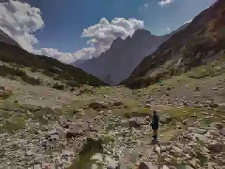
Ab der Reintalangerhütte erhöhte sich der Schwierigkeitsgrad deutlich. Die Wege zur Knorrhütte wurden steiler, enger und mit Schotter gefüllt. Etwa einen Kilometer bevor wir die Knorrhütte erreichten, verirrten wir uns versehentlich von der geplanten Route und nahmen den felsigen Aufstieg. Momo meisterte es bemerkenswert gut, mit ein paar Ruhepausen. Wir dachten, dass dies vielleicht der schwierigste Teil war, da wir auf einer Strecke von 1,7 km einen Höhenunterschied von etwa 1 km überwunden hatten. Zu diesem Zeitpunkt waren wir bereits auf 2.100 Metern und der Gipfel lag “nur” noch weitere 800 Meter höher. Allerdings setzte sich der steile Aufstieg direkt nach der Knorrhütte fort.
Von hier an gab es kein Grün mehr und folglich auch keine schattigen Bereiche, um Momo abzukühlen. Zum Glück gab es immer noch kleine Schneeflecken etwa alle 200 Meter, die Momo nutzte, um ihre Pfoten abzukühlen. Die Hitze war definitiv ihre größte Herausforderung.
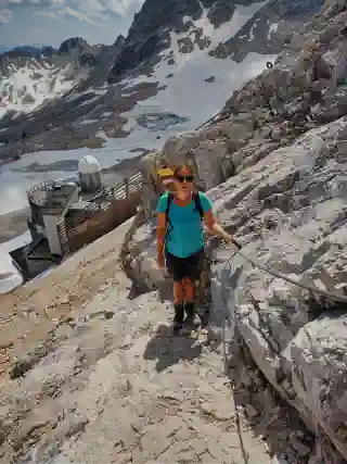
Schließlich kamen wir zur Sonnalpin, einer Basisstation mit einer Seilbahn, die Besucher zum Gipfel bringt. Für diejenigen, die sich an diesem Punkt müde fühlten, bestand die Möglichkeit, die Gondel zu nehmen, insbesondere da das Ticket für die Rückfahrt inbegriffen war. Für uns fühlte sich diese Option jedoch falsch an. Schließlich hätten wir dann nicht wirklich zur Zugspitze gewandert, oder?
Die Seilbahn zu nehmen hätte sich angefühlt, als würden wir einen bedeutenden Teil der Reise auslassen, und es hätte uns nicht dasselbe Gefühl von Erfolg und Erfüllung gegeben, wie wenn wir den Gipfel zu Fuß erreicht hätten. Also beschlossen wir trotz Müdigkeit, weiter zu wandern und uns selbst dazu zu bringen, den Gipfel der Zugspitze vollständig aus eigener Kraft zu erreichen.
Das Finale: Sonnalpin - Gipfelkreutz (2962 meters)
Dieser letzte Abschnitt war tatsächlich äußerst anspruchsvoll und angemessen mit einer schwarzen Schwierigkeitsstufe markiert. Zuerst mussten wir einen sehr steilen Schotterhang hinaufsteigen, der sehr locker war. Sogar Momo hatte Schwierigkeiten und rutschte ständig zurück, während sie sich mit allen Vieren bemühte. Einige unachtsame Wanderer mit ihren Stöcken und übergroßen Stiefeln lösten versehentlich große Felsen, die eine Gefahr für alle unterhalb darstellten. Nach etwa einer Stunde des Zickzack-Kletterns durch den Schotter erreichten wir das nächste Wegweiser-Schild, wo der Boden wieder fester wurde. Allerdings waren die Pfade entlang des Berghangs sehr schmal und steil, mit Steigungen von bis zu 78%. Zum Glück hatte der Alpenverein entlang des Weges Stahlseile zur Unterstützung installiert. Momo kämpfte mutig, und wir taten es auch, an ihrer Seite. Sie sprang auf Stufen, die etwa 1,5 Meter hoch waren, mit steilen Abgründen auf beiden Seiten. Momo war mit einer Leine an ihrem Geschirr gesichert, aber Georg sorgte immer dafür, eine Hand am Sicherheitsseil und die andere am Griff ihres Geschirrs zu haben. Dadurch konnten wir diese Hindernisse langsam, aber stetig überwinden. Wir sind unglaublich stolz auf Momo. Einerseits war sie sichtlich verängstigt und erschöpft, aber andererseits kletterte sie tapfer ohne Murren weiter. Man konnte wirklich sehen, dass sie wusste, dass ihr nichts Schlimmes passieren würde.
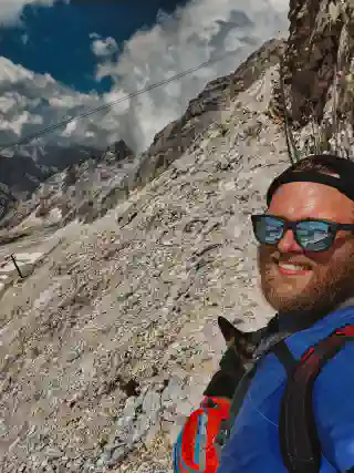
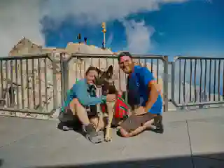
Am Ende erreichten wir den Gilpfel (das Münchnerhaus) der Zugspitze - ziehmlich k.o. aber glücklich.
Lustigerweise fühlten wir uns dort oben, mit all den Menschen, in Flip Flops die die Zugspitzbahn genommen haben, etwas seltsam. Wir suchten uns erstmal eine Bank und Momo konnte sich ausruhen.
Wie geplant nahmen wir dann die Vorletzte Bahn ins Tal.
Die Zugspitz-Seilbahn
Mit der Zugspitzbahn und der Zahnradbahn zurück nach Garmisch-Partenkirchen zu fahren, kostete den erschöpften Wanderer insgesamt dann 37€ (da beide zusammen). Die Transportgebühr für den Hund beträgt 5€.
Wir waren froh die Zeiten der Bahn vorher überprüft zu haben. Sonst kann es auch sehr eng mit er Zeit weren.
Das Beste für den Hund
Zu guter Letzt möchten wir betonen, dass das Wohlergehen unseres Hundes für uns von höchster Bedeutung ist!
Eine angemessene Vorbereitung und Nachsorge sind unerlässlich, wenn man eine solche Tour mit einem Hund unternimmt.
Ausreichend Schlaf und Ruhe vorher und nachher, gutes und reichliches Futter anbieten sowie Pfotenbalsam auftragen, um die Pfoten zu beruhigen, die während einer solchen Wanderung stark beansprucht werden. Zum Zeitpunkt der Tour war Momo eine 1,7 Jahre alte Hündin und sehr fit, was es uns ermöglichte, sie mit gutem Gewissen mitzunehmen. Je nach Fitnesslevel des Hundes entscheidet sich, ob eine solche Tour für ihn geeignet ist.
Packliste für eine Tageswanderung (mit Hund)
Wir lieben Wandern.
Wir wandern auch gerne außerhalb Deutschlands, zum Beispiel zur Elbquelle in der Tschechischen Republik, in den Sarek-Nationalpark in Schweden oder auf den Psiloritis, den höchsten Berg Kretas. Damit du nicht immer darüber nachdenken musst, was du brauchst, hier ist unsere Packliste:
Kleidung
- Funktionshemd Wir schwören auf Merino-Hemden nach zahlreichen Tests und nutzen sie jetzt hauptsächlich. Das Großartige ist, dass du sie sogar nach langen Wanderungen einfach auslüften und wieder tragen kannst! Das ist besonders praktisch für uns, da wir nur begrenzt Kleidung und Waschmöglichkeiten haben.
- Outdoorhose Zip-off-Hosen sind unsere Favoriten, da sie dich für jedes Wetter bereit machen.
- Wandersocken (Du findest sie mit und ohne Wollanteil, beide haben Vor- [ ] und Nachteile, und wir haben je ein Paar von jedem Typ.)
- Gut eingelaufene Wanderschuhe. Wir empfehlen dringend, Wanderschuhe im Laden zu kaufen. Das Gefühl in einem Schuh und die Möglichkeit, Schuhe ausgiebig zu vergleichen, sind entscheidend, wenn es um Wanderschuhe geht, da du eine beträchtliche Strecke zurücklegst.
- Kopfbedeckung, je nach Jahreszeit kann eine Mütze für Kälte und beißenden Wind oder eine Kappe für die Sonne wirklich nützlich sein.
- Jacke, es könnte jederzeit regnen oder du beginnst deine Wanderung morgens, wenn es noch nicht sehr warm ist. Die Jahreszeit, in der du wanderst, ist ebenfalls entscheidend. Aber denke daran, dass du die Jacke tagsüber in deinem Rucksack verstauen musst, wenn es warm wird!
Verpflegung
-
Wasser in wiederverwendbaren Flaschen. Unterwegs findest du vielleicht Wasserstellen. Deshalb lieben wir unsere Edelstahlflaschen, die wir schon lange haben.
-
Äpfel und Karotten, wir mögen sie beide, und auch unsere Hunde mögen sie.
-
Nussmischung
-
Sandwiches
Georg ist der Meister im Sandwich-Machen für uns. Wenn wir wandern gehen, achtet er darauf, dass die Füllungen das Brot nicht durchweichen, wie z. B. Marmelade. Käse funktioniert gut (einschließlich veganer Alternativen), besonders mit ein paar Gurken obendrauf. Aber auch Gurkensandwiches sind ausgezeichnet!
Technik
- Mobiltelefon
- Powerbank und das entsprechende Kabel
Denke daran, die richtige Karte für deine Wanderung im Voraus herunterzuladen und zu speichern. Nicht überall gibt es Empfang.
Optional:
- Stativ
- Kamera
Beide wiegen und können deinen Rucksack schnell überlasten, also überlege genau, ob du das zusätzliche Gewicht tragen möchtest.
Gesundheit
- Erste-Hilfe-Set
- Falls nicht im Erste-Hilfe-Set enthalten, Blasenpflaster
- Sonnencreme
- Toilettenpapier
- Vaseline für Blasen und die schmerzenden Pfoten deines Hundes!
Sonstiges
-
Wander-Rucksack für Menschen und Hunde
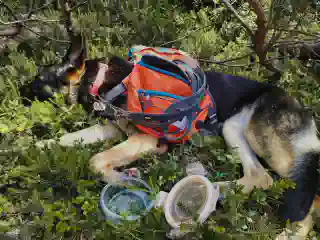
Es gibt auch Hunde-Wander-Rucksäcke, und Momo ist groß genug, um ziemlich viel zu tragen. Aber denke beim Packen daran, dass es nicht mehr als 3% ihres Körpergewichts sein darf!
-
Ausweis, Versicherungskarte
-
Sonnenbrille
-
Kleine Mülltüte für Abfall
-
Taschenmesser
-
Stirnlampen (besonders für Wanderungen im Herbst und Frühjahr, aber vergiss nicht, sie vorher aufzuladen!)
-
Insektenschutzmittel
-
Ein wenig Geld in der lokalen Währung
Für den Hund
- Hundewander-Rucksack (achte bitte darauf, ihn nicht zu überladen!)
- Leine
- Geschirr und Halsband
- Trinkflasche
- Trockenfutter/Trockenleckerlis
- Trinknapf
- Vaseline (im Erste-Hilfe-Set enthalten)